A6108 road
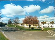
A-road in North Yorkshire, EnglandThe A6108 road is an A road in North Yorkshire, England. It runs from the south of Scotch Corner to Ripon going via Richmond and Leyburn across the moors and the valleys of Swaledale and Wensleydale. The road is 37 miles (60 km) long, but through traffic between the two destinations will find a shorter route of 26 miles (42 km) by going south on the A1. The route is single carriageway for its entire length.
Read article


Top Questions
AI generatedMore questions
Nearby Places

Middleham Castle
12th-century castle in Middleham, England

Middleham
Market town in North Yorkshire, England

River Cover
River in North Yorkshire, England
East Witton
Village and civil parish in North Yorkshire, England

Spennithorne
Village and civil parish in North Yorkshire, England

Church of St Mary and St Alkelda, Middleham
Church in North Yorkshire, England
Ulshaw
A hamlet in North Yorkshire, England

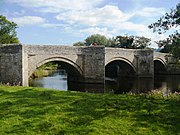
Ulshaw Bridge
Bridge in North Yorkshire, England